Colorado’s 300+ days of sunshine lend to year-round hiking, and if it’s too snowy, just throw on snowshoes and “hike” that way. Hiking in Colorado Springs can range from paved trails safe for strollers and youngsters on bikes to much more challenging terrain.
For the most part, you can find a length of the trail, scenery, and a difficulty level that suits your needs.
There are miles of trails in the Pikes Peak region and this is certainly not meant as an exhaustive list of trails, but rather those trails that reach the rank of personal favorite for us at Springs Homes.
There are a few things to remember about hiking in Colorado Springs from a safety and courtesy standpoint.
- On most trails, dogs must be on a leash and you must clean up after them.
- Users of trails must be powered by muscles, not motors (horses, people. bikes, etc… just no motorized vehicles).
- Prepare to see wildlife, but keep a safe distance (mostly deer, squirrels, rabbits, maybe fox.. and the occasional bear, snake, etc.).
- Come prepared. We live in a dry climate with lots of sunshine, so water, food, and sun protection are a must.
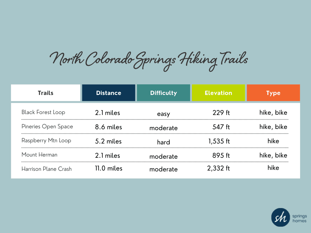
North Colorado Springs Hiking Trails
Trails in the northern part of Colorado Springs tend to be heavily treed and can have some spectacular views. The best time for day hikes in this area is from May to October as this area is at a higher elevation and generally has snow longer into the hiking season.
- Black Forest Loop – This is a 2.1-mile heavily trafficked loop trail located near USAF Academy with beautiful wildflowers and is appropriate for all abilities. The trail is best used from March until October. Dogs are also able to use this trail but must be kept on a leash. 2.1 miles, easy, 229 ft elevation gain, hiking, and biking
- The Pineries Open Space – The Pineries is an 8.6-mile moderately popular loop trail located near Peyton, Colorado that features a river and is good for all abilities. Horses are also able to use this trail. 8.6 miles, Moderate, 547 ft elevation gain, hiking, and biking
- Raspberry Mountain Loop – This loop is a 5.2-mile moderately trafficked loop trail located near Monument, Colorado that is rated as difficult. The trail is primarily used for hiking, running, and nature trips and is best visited from May until October. Dogs are also able to use this trail. 5.2 miles, Hard, 1,535 elevation gain, hiking
- Mount Herman Trail – The Mount Herman Trail is a 2.1-mile popular out and back trail located near Monument, Colorado that is rated as moderate and reveals tremendous views of the area from the top. The trail is primarily used for hiking and mountain biking and is best used from June until October. Dogs are also able to use this trail but must be kept on a leash. 2.1 miles, Moderate, 895 elevation gain, hiking, and biking
- Harrison Plane Crash Via Ice Cave Trail – The locally famous Harrison Plane Crash can be reached via an 11-mile moderately busy out and back trail located near Palmer Lake, Colorado named the Ice Cave Trail. The trail is primarily used for hiking and is best used from May until October. 11 miles, Moderate, 2,332 elevation gain, hiking
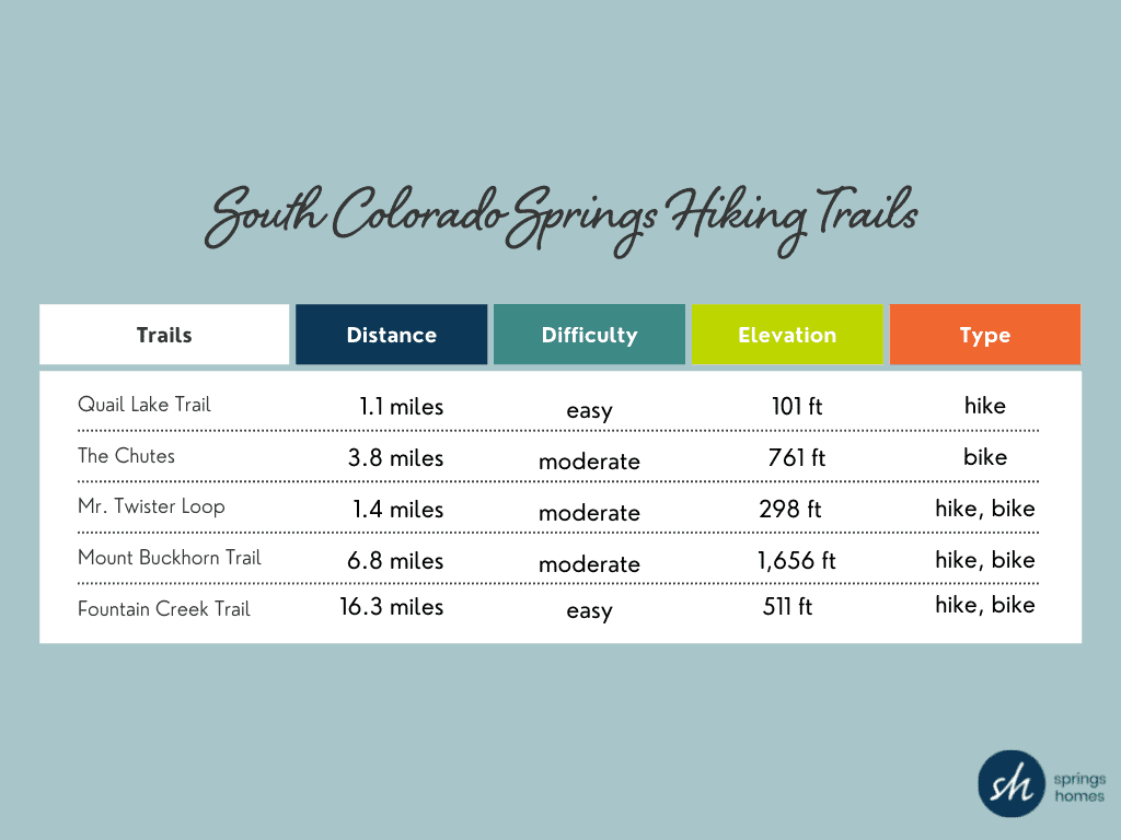
South Colorado Springs Hiking Trails
The south part of Colorado Springs has some of the best hiking trails and challenges for mountain bikers. Bear Creek Park, North Cheyenne Creek, Gold Camp Road, and Cheyenne Mountain State Park are all areas to check out. Some less popular trails tend to be some of our favorite Colorado Springs hikes.
- Quail Lake Trail – Quail Lake is a quaint lake right outside of the city limits of downtown Colorado Springs. There are great views of Pikes Peak and some easy trails perfect for families. The main trail is a 1.1-mile loop good for all skill levels and primarily used for hiking, walking, and trail running. Dogs are also able to use this trail but must be kept on a leash. 1.1 miles, Easy, 101 elevation gain, hiking
- The Chutes – Calling all mountain bikers! The Chutes Trail is a 3.8-mile popular loop trail located in the south part of Colorado Springs that features a lake and is rated as moderate. The trail is primarily used for mountain biking and is accessible year-round. 3.8 miles, Moderate, 761 elevation gain, biking only
- Mr. Twister Loop – This loop is a 1.4-mile moderately trafficked loop trail located near Colorado Springs, Colorado that is rated as moderate. The trail starts near Cheyenne Mountain High School and is best used from April until September. 1.4 miles, Moderate, 298 elevation gain, hiking, and biking
- Mount Buckhorn Trail to Seven Bridges – This trail is a 6.8-mile moderately trafficked moderately difficult loop trail near Helen Hunt Falls and Seven Bridges Trail. The trail is primarily used for hiking, running, nature trips, and mountain biking and is best used from April until December. Dogs are also able to use this trail. 6.8 miles, Moderate, 1,656 elevation gain, hiking, and biking
- Fountain Creek Regional Trail – Fountain Creek Regional Park is home to a great Nature Center and Visitor Center as well as the main Trail which is a 16.3-mile moderately trafficked out and back trail located near Fountain. The trail is primarily used for hiking, walking, running, and mountain biking. Dogs are also able to use this trail but must be kept on a leash. 16.3 miles, easy, 511 elevation gain, hiking, and biking
East Hiking Trails
Hiking trails on the east side of Colorado Springs tend to be a little flatter and less treed. The Austin Bluffs Open Space, Pulpit Rock, and Palmer Park are some of the best places for mountain views. Far out east, the Paint Mines Interpretive Park is a great place for a day hike. Here are some more of our favorite trails in this area.
- Sand Creek Trail – The Sand Creek Trail is a 5.3-mile moderately popular out and back trail along the creek that is good for all skill levels. 5.3 miles, easy, 232 elevation gain, hiking, and biking
- Homestead Trail – Homestead Trail is a 6.4-mile moderately trafficked out and back trail located near Powers Blvd and N Carefree. The trail parallels Powers Blvd and is perfect for those wanting an easy trail. 6.4 miles, easy, 649 elevation gain, hiking, and biking
- Yucca, Mesa, and Edna Mae Bennet Short Loop Trail- This Palmer Park trail is a 1.8-mile lightly trafficked loop trail located near Colorado Springs, Colorado that offers the chance to see wildlife and is rated as moderate. The trail is primarily used for hiking, walking, running, and mountain biking. Dogs are also able to use this trail but must be kept on a leash. 1.8 miles, moderate, 187 elevation gain, hiking, and biking
- Palmer Park Outer Loop Trail – The Palmer Park Outer Loop Trail is a 7.4-mile popular hiking trail located near the center of Colorado Springs. The trail offers a number of activity options and is best used from March until November. Dogs and horses are also able to use this trail. 7.4 miles, moderate, 849 elevation gain, hiking, and biking
- Rock Island Trail – The Rock Island Trail is a 17.1-mile lightly used out and back trail located east of Colorado Springs. Dogs and horses are also able to use this trail. 17.1 miles, 232 elevation gain, hiking, and biking.

West Hiking Trails
Known for its beautiful rock formations and drop-dead gorgeous scenery, the Westside and Manitou Springs area of Colorado Springs battle it out for the most popular trail. Manitou Incline, Siamese Twins Trail, Barr Trail, Red Rock Canyon Open Space, and Garden of the Gods Park are some of the most highly used trails with some magnificent red rock formations. Here are some additional trails that are always fun.
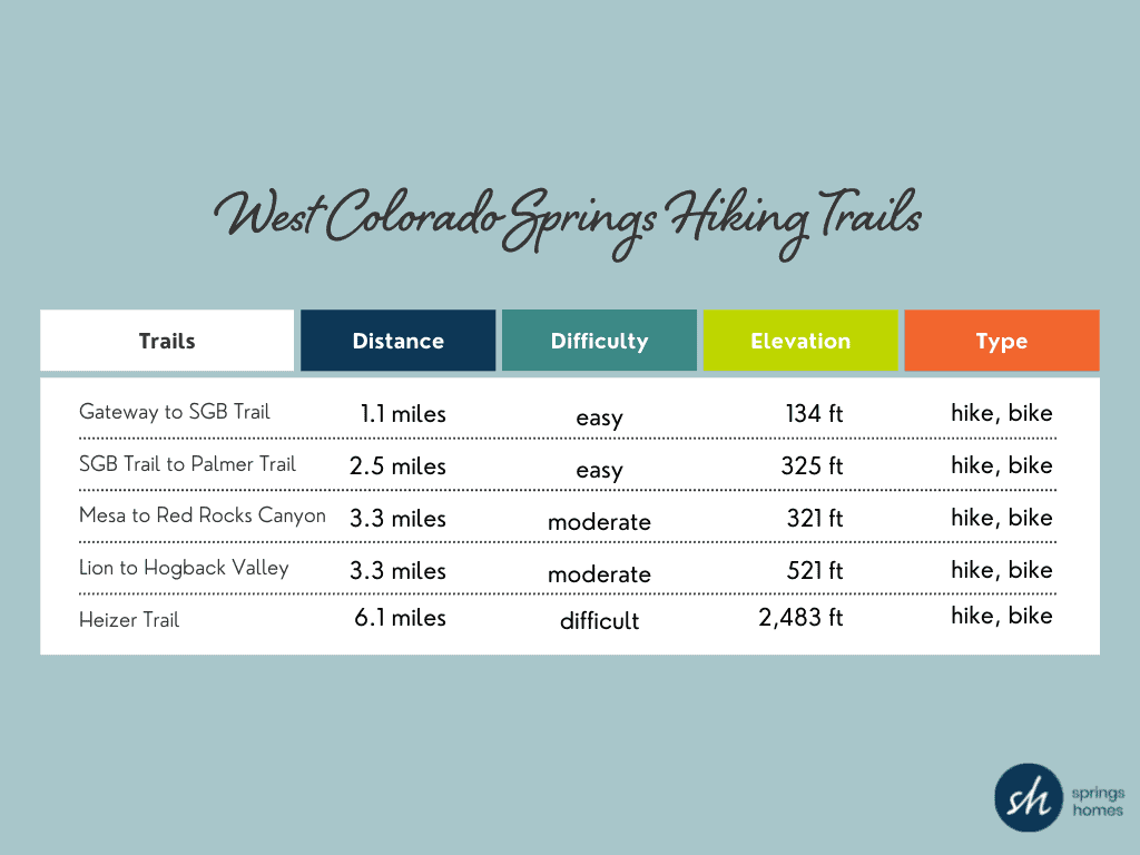
- Gateway and Susan G Bretag Trail – This trail is a 1.1-mile lightly used loop trail located near the Rock Ledge Ranch Historic site that offers the chance to see wildlife. The trail is good for all skill levels and offers a number of activity options. Dogs are also able to use this trail but must be kept on a leash. 1.1 miles, easy, 134 elevation gain, hiking, and biking
- Susan G Bretag Trail and Palmer Trail Loop – This loop is a 2.5-mile heavily trafficked loop trail traveling through the Garden of the Gods. Dogs are also able to use this trail but must be kept on a leash. There is also an off-leash dog park nearby. 2.5 miles, easy, 321 elevation gain, hiking, and biking
- Mesa Trail to Red Rocks Canyon Trail – This 3.3-mile loop trail is located in Red Rock Canyon Open Space. The trail is moderate and is suited for hiking and biking and offers miles of hiking with great red rock views. 3.3 miles, Moderate, 521 elevation gain, hiking, and biking
- Lion Trail and Hogback Valley Loop – This loop in Red Rock Canyon starts from Parking Lot 3 and is a 3.3-mile moderately trafficked loop trail. This trail offers scenic views and is rated as moderate. The trail is best used from April until October. 3.3 miles, Moderate, 521 elevation gain, hiking, and biking
- Heizer Trail – Hold onto your hats, the Heizer Trail is a 6.1 mile heavily trafficked out and back trail located near Cascade. This trail follows the river and is rated as difficult and should be used by an experienced hiker. The trail is primarily used for hiking and mountain biking and is best used from May until October. 6.1 miles, Hard, 2,483 elevation gain, hiking, and biking.
For additional things to do in Colorado Springs, visit our blog.
The voyage had begun, and had begun happily with a soft blue sky, and a calm sea.
They followed her on to the deck. All the smoke and the houses had disappeared, and the ship was out in a wide space of sea very fresh and clear though pale in the early light. They had left London sitting on its mud. A very thin line of shadow tapered on the horizon, scarcely thick enough to stand the burden of Paris, which nevertheless rested upon it. They were free of roads, free of mankind, and the same exhilaration at their freedom ran through them all.
The ship was making her way steadily through small waves which slapped her and then fizzled like effervescing water, leaving a little border of bubbles and foam on either side. The colourless October sky above was thinly clouded as if by the trail of wood-fire smoke, and the air was wonderfully salt and brisk. Indeed it was too cold to stand still. Mrs. Ambrose drew her arm within her husband’s, and as they moved off it could be seen from the way in which her sloping cheek turned up to his that she had something private to communicate.